Peace River (Canada)
- This article is about the river. For the town in Alberta see Peace River, Alberta. For other uses see Peace River
| Peace River | |
|---|---|
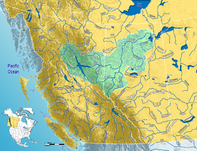 Peace River watershed in western Canada |
|
| Origin | Finlay River |
| Mouth | Slave River |
| Basin countries | Canada |
| Length | 1,923 km |
| Source elevation | 671 m (mouth of Finlay River) 1,200 m (Finlay headwater-Thutade Lake) |
| Mouth elevation | 213 m |
| Avg. discharge | 2161 m3/s 68,200,000 dam3/a |
| Basin area | 302,500 km2 |
The Peace River (French: rivière de la Paix) is a river in Canada that originates in the Rocky Mountains of northern British Columbia and flows through northern Alberta. The Peace River flows into the Slave River, a tributary of the Mackenzie River. The Mackenzie is the 12th longest river in the world, preceded by the Mekong and followed by the Niger River. The Finlay River, the main headwater of the Peace River, is regarded as the ultimate source of the Mackenzie River. It is reported to have over twice the flow rate of the Nile.
Contents |
History
The regions along the river are the traditional home of the Dunne-za or Beaver people. The fur trader Peter Pond is believed to have visited the river in 1785. In 1788 Charles Boyer of the North West Company established a fur trading post at the river's junction with the Boyer River.
In 1792 and 1793, the explorer Alexander Mackenzie travelled up the river to the Continental Divide.[1] Mackenzie referred to the river as "Unjegah", from a native word meaning "large river". The Peace River, or Unchaga or Unjaja, was named after Peace Point near Lake Athabasca, where the Treaty of the Peace came authorized with the smoking of a peace pipe. The treaty ended the decades of hostilities between the Beaver (Athapascan branch) and the Cree in which the Cree dominated the Beaver until a smallpox epidemic in 1781 decimated the Cree. The treaty made the Beaver stay north of the river and the Cree south.[2]
In 1794, a fur trading post was built on the Peace River at Fort St. John, which was the first non-native settlement on the British Columbia mainland.
The rich soils of the Peace River valley in Alberta have been producing wheat crops since the late 19th century. The Peace River region is also an important centre of oil and natural gas production. There are also pulp and paper plants along the river in British Columbia.
Geography
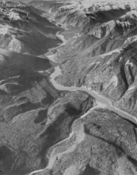
Course
This river is 1,923 km long (from the head of Finlay River to Lake Athabasca). It drains an area of approximately 302,500 km2.[3] At Peace Point, where it drains in the Slave River, it has an annual discharge of 2161 m3/s or 68,200,000 dam3/a.[4]
A large man-made lake, Williston Lake, has been formed on the upper river by the construction of the W. A. C. Bennett Dam for hydroelectric power generation. The river then flows into Dinosaur Lake, which serves as a reservoir for the Peace Canyon Dam. After the dams, the river flows east into Alberta and then continues north and east into the Peace-Athabasca Delta in Wood Buffalo National Park, at the western end of Lake Athabasca. Water from the delta flows into the Slave River east of Peace Point and reaches the Arctic Ocean via the Great Slave Lake and Mackenzie River.
Communities
Communities located directly on the river include:
- Hudson's Hope, British Columbia
- Taylor, British Columbia
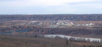
- Peace River, Alberta
- Fort Vermilion, Alberta
Many provincial parks and wildland reserves are established on the river, such as Butler Ridge Provincial Park, Taylor Landing Provincial Park, Beatton River Provincial Park, Peace River Corridor Provincial Park in British Columbia and Dunvegan Provincial Park, Dunvegan West Wildland, Peace River Wildland Provincial Park, Greene Valley Provincial Park, Notikewin Provincial Park, Wood Buffalo National Park in Alberta.
A few Indian reserves are also located on the river banks, among them Beaver Ranch 163, John D'Or Prairie 215, Fox Lake 162, Peace Point 222 and Devil's Gate 220.
Tributaries
Tributaries of the Peace River include:
- Williston Lake
- Finlay River
- Omineca River
- Ingenika River
- Ospika River
- Parsnip River
- Manson River
- Nation River
- Clearwater Creek
- Nabesche River
- Carbon Creek
- Northeastern British Columbia
- Gething Creek, Moosbar Creek, Johnson Creek, Starfish Creek, Bullrun Creek, Portage Creek, Maurice Creek, Lynx Creek, Farrell Creek
- Halfway River
- Cache Creek, Wilder Creek, Tea Creek
- Moberly River
- Pine River
- Eight Mile Creek
- Beatton River
- Doig River
- Blueberry River
- Golata Creek, Mica Creek
- Kiskatinaw River
- Alces River
- Alberta
- Moonlight Creek
- Pouce Coupe River
- Clear River
- Sneddon Creek
- Montagneuse River
- Fourth Creek, Hamelin Creek
- Ksituan River
- Hines Creek, Dunvegan Creek, Boucher Creek
- Leith River (Little Burnt River)
- Saddle River (Burnt River)
- Griffin Creek, Mcallister Creek, Strong Creek
- Smoky River
- Heart River
- Pats Creek, Three Creeks, Carmon Creek
- Whitemud River
- Cadotte River
- Buchanan Creek, Keppler Creek
- Notikewin River
- Scully Creek
- Wolverine River
- Buffalo River
- Keg River
- Steephill Creek
- Boyer River
- Caribou River
- Beaver Ranch Creek
- Wabasca River
- Lawrence River
- Mikkwa River (Little Red River)
- Dummy Creek, Waldo Creek
- Pakwanutik River
- Garden Creek, Drolet Creek, Swan River, Vermilion River, Trident Creek, Portage River
- Jackfish River
- Jodoin Creek
- Claire River
- Lake Claire
- Lake Claire
- Birch River
- McIvor River
- Mamawi Lake
- Baril River
- Chenal Des Quatre Fourches
- Revillon Coupe
- Scow Channel
References
- ↑ Peace River. (2006). In Encyclopædia Britannica. Retrieved September 12, 2006, from Encyclopædia Britannica Premium Service
- ↑ Coutts, M. E. (1958). Dawson Creek: Past and Present, An Historical Sketch. Edmonton: Dawson Creek Historical Society.
- ↑ Atlas of Canada. "Rivers in Canada". http://atlas.nrcan.gc.ca/site/english/learningresources/facts/rivers.html. Retrieved 2007-05-01.
- ↑ Alberta Environment - Alberta river basins
External links
|
|||||||||||||||||||

|
|||||||||||